dryfj.com / drycyclist.com (kevin cook)
2744/7119
Home
/
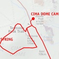
Cima Dome / Teutonia Peak hike route as viewed in Google Earth
Thumbnails
Previous
Next
Photo sizes
Photo sizes
✔
XXS - tiny
(244 x 180)
✔
XS - extra small
(432 x 319)
✔
S - small
(576 x 426)
✔
M - medium
(792 x 586)
✔
Original
(850 x 629)
slideshow
Albums
Mojave Preserve and Desert bikepacking trips
/
2008: Mojave National Preserve Mountain-Bike Camping and Hike
/
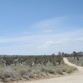
Day 13: Day hike up to Teutonia Peak then looping around the west side of Cima Dome via Deer Spring, Mojave National Preserve
Powered by
Piwigo
Join me on Facebook

)
)
)
)
)