2746/7119
Home /
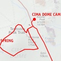
About 1.5 miles before reaching the Cima Store, I pass that power-line road again that crosses Mojave National Preserve
 by riding this rough road. A stop at remote Marl Springs, which I visited on my 2006 trip, to filter some water would be a fun diversion along the way.
I've ridden various segments of this power-line road over the years, but I've not ridden the part that extends from here to Marl Springs.")
If my bike rack weren't broken, I could shave a few miles off today's ride (though it would probably take longer) by riding this rough road. A stop at remote Marl Springs, which I visited on my 2006 trip, to filter some water would be a fun diversion along the way.
I've ridden various segments of this power-line road over the years, but I've not ridden the part that extends from here to Marl Springs.
)
)
)
)
)