dryfj.com / drycyclist.com (kevin cook)

3827/7119
Home /

Elevation profile of bicycle route from Twin Buttes campsite to Nipton via Cima: Day 15

nipton-elevation.jpg I recharge my cell phone and my headlight battery in the shower building before leaving NiptonThumbnailsBicycle route from Twin Buttes campsite to Nipton via Cima: Day 15I recharge my cell phone and my headlight battery in the shower building before leaving NiptonThumbnailsBicycle route from Twin Buttes campsite to Nipton via Cima: Day 15I recharge my cell phone and my headlight battery in the shower building before leaving NiptonThumbnailsBicycle route from Twin Buttes campsite to Nipton via Cima: Day 15I recharge my cell phone and my headlight battery in the shower building before leaving NiptonThumbnailsBicycle route from Twin Buttes campsite to Nipton via Cima: Day 15I recharge my cell phone and my headlight battery in the shower building before leaving NiptonThumbnailsBicycle route from Twin Buttes campsite to Nipton via Cima: Day 15I recharge my cell phone and my headlight battery in the shower building before leaving NiptonThumbnailsBicycle route from Twin Buttes campsite to Nipton via Cima: Day 15

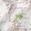
50.9 often-downhill bicycle miles. High point of the day on Black Canyon Road: 5346 feet elevation; low point (near Nipton): 2624 feet elevation.