dryfj.com / drycyclist.com (kevin cook)

4889/7119
Home /

Bicycle route from Brant Hills to Baker via old Mojave Road, Mojave National Preserve

mojave-road-route.jpg Elevation profile of bicycle route from Brant Hills to Baker via old Mojave Road, Mojave National PreserveThumbnailsI stop briefly at Kelbaker Road's 10-mile curve, which means just 10 more miles until I reach BakerElevation profile of bicycle route from Brant Hills to Baker via old Mojave Road, Mojave National PreserveThumbnailsI stop briefly at Kelbaker Road's 10-mile curve, which means just 10 more miles until I reach BakerElevation profile of bicycle route from Brant Hills to Baker via old Mojave Road, Mojave National PreserveThumbnailsI stop briefly at Kelbaker Road's 10-mile curve, which means just 10 more miles until I reach BakerElevation profile of bicycle route from Brant Hills to Baker via old Mojave Road, Mojave National PreserveThumbnailsI stop briefly at Kelbaker Road's 10-mile curve, which means just 10 more miles until I reach BakerElevation profile of bicycle route from Brant Hills to Baker via old Mojave Road, Mojave National PreserveThumbnailsI stop briefly at Kelbaker Road's 10-mile curve, which means just 10 more miles until I reach BakerElevation profile of bicycle route from Brant Hills to Baker via old Mojave Road, Mojave National PreserveThumbnailsI stop briefly at Kelbaker Road's 10-mile curve, which means just 10 more miles until I reach Baker

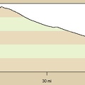
51.9 bicycle miles with 1600 feet of elevation gain and 4600 feet of elevation loss (exaggerated by the GPS software).