dryfj.com / drycyclist.com (kevin cook)

6717/7119
Home /

The climb up Cedar Canyon Road into the Mid Hills starts out well

01913-mojave-road.jpg Cedar Canyon Road dips down into Cedar Wash for a couple of milesThumbnailsI pull in at the road to Chicken Water Spring and try my cell phone; it works here as hopedCedar Canyon Road dips down into Cedar Wash for a couple of milesThumbnailsI pull in at the road to Chicken Water Spring and try my cell phone; it works here as hopedCedar Canyon Road dips down into Cedar Wash for a couple of milesThumbnailsI pull in at the road to Chicken Water Spring and try my cell phone; it works here as hopedCedar Canyon Road dips down into Cedar Wash for a couple of milesThumbnailsI pull in at the road to Chicken Water Spring and try my cell phone; it works here as hopedCedar Canyon Road dips down into Cedar Wash for a couple of milesThumbnailsI pull in at the road to Chicken Water Spring and try my cell phone; it works here as hoped

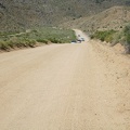
Behind me here at about 3800 feet, the old Mojave Road is clearly visible winding up toward Marl Springs in the Marl Mountains.