31/71
Home / Mojave Preserve and Desert bikepacking trips / Spring 2011: Mojave National Preserve and area bicycle camping / Day 7: Castle Peaks Road to Mid Hills Campground, Mojave National Preserve, by bicycle via Lanfair Valley /
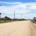
I've been riding Ivanpah Road for over two hours; I'll turn right onto Cedar Canyon Road just ahead

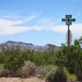
According to the sign, I have 20 miles until I reach Mid Hills campground, or 24 to Hole-in-the-Wall campground. I haven't decided yet which one is my destination.
)
)
)
)
)