dryfj.com / drycyclist.com (kevin cook)

1436/7119
Home /

After another 20 minutes, I reach the top of the wash and locate the old Castle Peaks road

3082-castle-peaks.jpg The sandy wash radiates from the golden end-of-day sunlightThumbnailsThe old Castle Peaks road leaves the pinnacles area and dips down between rolling hills on the way back to my campsiteThe sandy wash radiates from the golden end-of-day sunlightThumbnailsThe old Castle Peaks road leaves the pinnacles area and dips down between rolling hills on the way back to my campsiteThe sandy wash radiates from the golden end-of-day sunlightThumbnailsThe old Castle Peaks road leaves the pinnacles area and dips down between rolling hills on the way back to my campsiteThe sandy wash radiates from the golden end-of-day sunlightThumbnailsThe old Castle Peaks road leaves the pinnacles area and dips down between rolling hills on the way back to my campsiteThe sandy wash radiates from the golden end-of-day sunlightThumbnailsThe old Castle Peaks road leaves the pinnacles area and dips down between rolling hills on the way back to my campsite

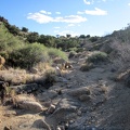
At a junction of two old, closed roads here, I start walking down the wrong one, but turn around after about 30 seconds when I realize the scenery is wrong. This point is at about 5175 feet elevation here.