28/32
Home / Mojave Preserve and Desert bikepacking trips / Fall 2010: Route 66 and Kelso Dunes Wilderness Bicycle Camping / Day 4: South Bristol Mountains foothills campsite to Broadwell Dry Lake by bicycle, with a detour to Ludlow for water /
Crucero Road by the dry lake turns out to be firm-surfaced (but rough), so I happily ride the final 4 miles at a cool 7 mph

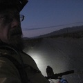
Disbelief: traction problems gone! But in total desert darkness, I can't find the side road to Old Dominion Mine when I reach it. I follow the GPS route I prerecorded, not sure if I'm on the road or hiking the bike cross-country through the creosote bushes.
The road has probably moved a bit over the years since the USGS maps were made, and I'm probably right next to it, but I still don't see it after bike-hiking it for half a mile.
I don't want to go all the way up to the former Old Dominion Mine site in case there is old debris there that makes loud noises in the wind and disturbs my sleep.
)
)
)
)
)