16/43
Home / Mojave Preserve and Desert bikepacking trips / 2008: Mojave National Preserve Mountain-Bike Camping and Hike / Day 6: Coyote Springs to Butcher Knife Canyon via Kelso Depot and Death Valley Mine Road, Mojave National Preserve /
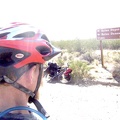
I take another break when I reach the end of my Kelso-Cima Road climb at the junction of Cedar Canyon Road
.")
A marker commemorates the old Mojave Road that leaves from this intersection and heads up to Marl Springs.
It took me about 2 1/4 hours to climb the 14.5 miles of Kelso-Cima Road with 1600 feet of elevation gain.
I visited Marl Springs on my 2006 trip and rode a few miles of the Mojave Road, but Bicycle Joe travelled almost all of the Mojave Road by bicycle in 2008 (way to go Joe!).
)
)
)
)
)