dryfj.com / drycyclist.com (kevin cook)

6139/7119
Home /

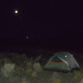
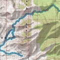
Hiking route profile from Pachalka Spring up a canyon on the north side of the Clark Mountain Range (Day 14)

north-clark-mtn-profile.jpg One of my after-dark photos tonight is actually usable; usually they are notThumbnailsMojave National Preserve hiking route from Pachalka Spring up a canyon on the north side of the Clark Mountain Range (Day 14)One of my after-dark photos tonight is actually usable; usually they are notThumbnailsMojave National Preserve hiking route from Pachalka Spring up a canyon on the north side of the Clark Mountain Range (Day 14)One of my after-dark photos tonight is actually usable; usually they are notThumbnailsMojave National Preserve hiking route from Pachalka Spring up a canyon on the north side of the Clark Mountain Range (Day 14)One of my after-dark photos tonight is actually usable; usually they are notThumbnailsMojave National Preserve hiking route from Pachalka Spring up a canyon on the north side of the Clark Mountain Range (Day 14)One of my after-dark photos tonight is actually usable; usually they are notThumbnailsMojave National Preserve hiking route from Pachalka Spring up a canyon on the north side of the Clark Mountain Range (Day 14)

8.7 hiking miles with 2970 feet of elevation gain (from 4870 feet, down to 4450 feet, then up to 6350 feet, and back).