dryfj.com / drycyclist.com (kevin cook)

8/44
Home / Mojave Preserve and Desert bikepacking trips / 2009, Spring: Mojave National Preserve / Day 13: Copper World Mine day hike from Pachalka Spring, Mojave National Preserve /

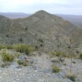
A little higher up the hill, looking west toward Valley Wells, where I stopped at the store yesterday

03920-pachalka-spring.jpg My route up the hill is as steep as anticipated and has great views back down toward the washThumbnailsA northwest view beyond three agave stems toward Pachalka Spring, with Kingston Range in the distance at the rightMy route up the hill is as steep as anticipated and has great views back down toward the washThumbnailsA northwest view beyond three agave stems toward Pachalka Spring, with Kingston Range in the distance at the rightMy route up the hill is as steep as anticipated and has great views back down toward the washThumbnailsA northwest view beyond three agave stems toward Pachalka Spring, with Kingston Range in the distance at the rightMy route up the hill is as steep as anticipated and has great views back down toward the washThumbnailsA northwest view beyond three agave stems toward Pachalka Spring, with Kingston Range in the distance at the rightMy route up the hill is as steep as anticipated and has great views back down toward the washThumbnailsA northwest view beyond three agave stems toward Pachalka Spring, with Kingston Range in the distance at the right

Valley Wells should be that small spot in the valley in the distance, the one with the vertical line (a dirt road) sprouting out of it, about 5.5 miles away. The Sawtooth is visible in the distance just right of centre.