12/24
Home / Mojave Preserve and Desert bikepacking trips / 2007: Henry Coe State Park Mountain-Bike Camping / Day 2: Sierra View camp to Mississippi Lake /
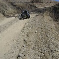
I finally meet the junction of Poverty Flat Road and Mahoney Meadows Road, and begin a short, fun, and steep downhill.
 to the next crossing of now-dry Coyote Creek at Los Cruzeros.
Mississippi Lake, today's destination, is on the other side of Willow Ridge, the big hill in front of me here that needs to be climbed.
Did someone say that yellow, blue and green aren't beautiful, and that California is all dry and ugly at this time of year?")
Yee-haw! I will descend 350 feet in 0.5 miles down this road to the bottom of the canyon below (not visible in photo) to the next crossing of now-dry Coyote Creek at Los Cruzeros.
Mississippi Lake, today's destination, is on the other side of Willow Ridge, the big hill in front of me here that needs to be climbed.
Did someone say that yellow, blue and green aren't beautiful, and that California is all dry and ugly at this time of year?

)
)
)
)
)