15/54
Home / Mojave Preserve and Desert bikepacking trips / 2008: Bikepacking in Henry Coe State Park / Day 2: Central Henry Coe day hike from Pacheco Camp, including Willow Ridge Road, Walsh Trail and Pacheco Ridge Road /
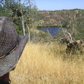
After White Rock Spring Trail, I walk south along the ridgetop on Willow Ridge Road
 down the hill to Coit Lake, but I stay up on the ridge.
I'm quite familiar with the parts of Willow Spring Road north of here and closer to Mississippi Lake (aka Roller Coaster Ridge ), but this part of the road is new to me.")
After a mile I reach this intersection with this road that runs east (left) down the hill to Coit Lake, but I stay up on the ridge.
I'm quite familiar with the parts of Willow Spring Road north of here and closer to Mississippi Lake (aka "Roller Coaster Ridge"), but this part of the road is new to me.

)
)
)
)
)